How Deep Is the Grand Canyon? Depth, Width & Length
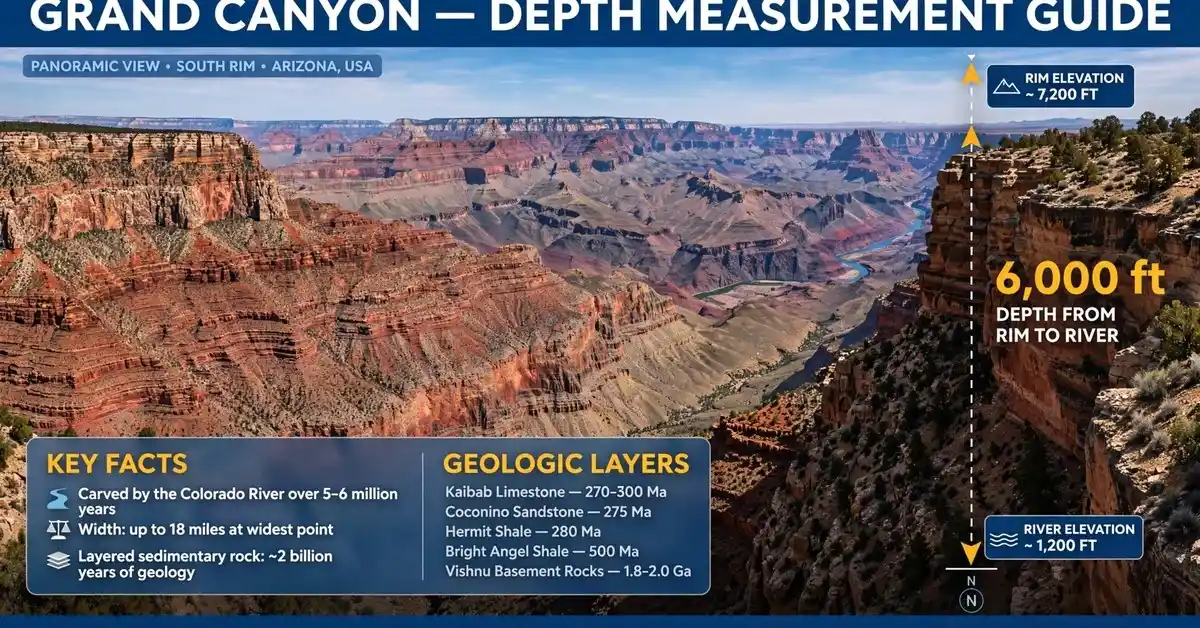
The Grand Canyon is about 6,000 feet (1,800 meters) deep at its deepest point, which is more than a mile straight down from rim to river. It stretches 277 miles long and spans between 4 and 18 miles wide, with the Colorado River running along its floor. To put that depth in everyday terms, you could stack four Empire State Buildings on top of each other inside it and still not reach the rim.
Numbers like these are hard to picture, so it helps to anchor them to things you already know. The same habit that makes a standard door a handy yardstick around the house works for the canyon too — except here the yardstick needs to be enormous. Below, we break the canyon down into 15 concrete measurements so you can really feel how big it is.
Depth & Size Conversion Chart
| Measurement | Feet | Meters | Miles | Kilometers |
|---|---|---|---|---|
| Maximum depth | 6,000 | 1,800 | 1.14 | 1.83 |
| Average depth | 5,280 | 1,609 | 1.0 | 1.61 |
| Length | 1,462,560 | 445,800 | 277 | 446 |
| Maximum width | 95,040 | 28,970 | 18 | 29 |
| Minimum width | 21,120 | 6,437 | 4 | 6.4 |
| South Rim elevation | 7,000 | 2,134 | 1.33 | 2.13 |
| North Rim elevation | 8,000 | 2,438 | 1.52 | 2.44 |
Grand Canyon Measurements at a Glance
| # | Feature | Measurement |
|---|---|---|
| 1 | Maximum depth | ~6,000 ft (1,800 m) |
| 2 | Average depth | ~1 mile (5,280 ft) |
| 3 | Length | 277 miles |
| 4 | Width (widest) | 18 miles |
| 5 | Width (narrowest) | 4 miles |
| 6 | South Rim elevation | ~7,000 ft |
| 7 | North Rim elevation | ~8,000 ft |
| 8 | Colorado River length inside the canyon | ~277 miles |
More Grand Canyon Scale Facts
| # | Feature | Measurement |
|---|---|---|
| 9 | Bright Angel Trail descent | ~4,400 ft |
| 10 | Kaibab limestone layer thickness | ~300–400 ft |
| 11 | Vishnu schist age | ~1.7 billion years |
| 12 | Inner Gorge depth | ~2,000 ft |
| 13 | Desert View Watchtower height | 70 ft |
| 14 | Hoover Dam comparison | 726 ft (canyon ~8x deeper) |
| 15 | Burj Khalifa comparison | 2,717 ft (fits twice over) |
1. Maximum Depth: About 6,000 Feet
The single most famous Grand Canyon number is its depth: roughly 6,000 feet from the North Rim down to the Colorado River. That is more than a mile of vertical drop, and it is what makes standing at the rim feel less like looking at a view and more like looking into another world.
Six thousand feet is hard to feel from a number alone. Think of it as descending the height of nearly five Empire State Buildings stacked end to end, or imagine walking downhill for over an hour at a steep grade and still not being halfway down. The deepest sections sit along the North Rim side of the canyon, where the rim rises highest above the river. Because the river keeps cutting downward while the plateau stays put, the depth is not a fixed ancient number — it is the current result of millions of years of erosion that is still slowly at work today.
2. Average Depth: Roughly One Mile
While the maximum depth grabs headlines, the canyon’s average depth of about one mile (5,280 feet) is arguably the more useful number. It describes the typical rim-to-river drop across most of the canyon’s length, smoothing out the deepest gorges and the shallower side canyons into one representative figure.
A mile of depth is a convenient benchmark because nearly everyone has walked or driven a mile. Now turn that mile vertical. The walk from your front door to the corner store, if pointed straight down, would just about get you from the South Rim to the river. Rangers and guidebooks use the one-mile figure constantly because it is honest: most visitors looking into the canyon are looking across roughly a mile of layered rock, and most hikers descending to the river will drop very close to that amount.
3. Total Length: 277 Miles
The Grand Canyon runs 277 miles from end to end, measured along the Colorado River from Lees Ferry to the Grand Wash Cliffs. That is roughly the driving distance between Los Angeles and San Diego, except instead of freeway it is all canyon.
The length matters because it explains why the canyon feels like a world of its own rather than a single landmark. You can stand at the South Rim and be more than 200 miles from the canyon’s western end, with entire side canyons, waterfalls, and desert stretches in between that few people ever see. The 277-mile figure follows the winding river rather than a straight line, which is why the canyon seems to twist and turn endlessly when viewed from the air.
4. Maximum Width: 18 Miles
At its widest point, the Grand Canyon stretches 18 miles from rim to rim. Stand on the South Rim at one of these wide sections and the North Rim is a distant blue line on the horizon, barely distinguishable from the sky.
Eighteen miles is wider than many cities are long. It is not a crack in the ground but a vast eroded landscape with its own mesas, weather, and ecosystems. From the widest overlooks you cannot even see the river, because the inner gorge hides it below the plateau’s edge. Visitors often expect to look down into a narrow chasm; instead they find a panorama so wide that a single glance cannot take it all in.
5. Minimum Width: 4 Miles
At its narrowest, the canyon is still about 4 miles wide — a fact that surprises people who imagine a slim slot canyon. Even where the rims pinch closest together, you are looking across a gap wider than most airport runways are long, several times over.
The 4-mile minimum typically occurs where the canyon’s walls are steepest and the inner gorge dominates the view. These narrower sections are where the river’s work is most visible, with sheer cliffs dropping directly toward the water. If you have ever stood at a viewpoint and felt the canyon was “close” enough to almost touch the other side, you were probably near one of these narrower stretches — and the far rim was still miles away.
6. South Rim Elevation: About 7,000 Feet
The South Rim sits at roughly 7,000 feet above sea level, which is higher than most visitors expect and explains the crisp air, the ponderosa pine forests, and the occasional snow in winter. Almost all first-time visitors arrive here, since it is open year-round and hosts the main visitor centers and lodges.
That 7,000-foot elevation is measured against sea level, not against the river — and the distinction matters. The river below sits at roughly 2,400 feet above sea level near the South Rim, so the famous one-mile depth is really the difference between these two elevations. The South Rim’s height also means the canyon you see from here is slightly shallower than the maximum depth found on the North Rim side.
7. North Rim Elevation: About 8,000 Feet
The North Rim rises to roughly 8,000 feet above sea level — about a thousand feet higher than the South Rim — which is why the canyon reaches its maximum depth of around 6,000 feet on this side. The extra elevation brings cooler temperatures, aspen and spruce forests, and a season that runs only from about mid-May to mid-October.
Because the North Rim is higher, the layers of rock visible from its viewpoints are slightly different, and the drop to the river is the longest anywhere in the canyon. The North Rim gets far fewer visitors, but those who make the trip are rewarded with the canyon at its most dramatic: deeper, wilder, and framed by high-elevation forest that feels nothing like the desert below.
8. The Colorado River: 277 Miles Through the Canyon
The Colorado River runs the full 277-mile length of the canyon, and it is the reason the canyon exists at all. Every foot of that depth was carved by water — the river cutting downward through rock while the Colorado Plateau slowly rose around it, over the course of millions of years.
Inside the canyon the river is a working river: it drops roughly 2,000 feet in elevation from Lees Ferry to the Grand Wash Cliffs, powering through more than 160 rapids along the way. Rafting the full length takes about two to three weeks.
9. Bright Angel Trail: A 4,400-Foot Descent
The Bright Angel Trail drops about 4,400 feet from the South Rim to the Colorado River over roughly 9.5 miles of switchbacks, making it the most popular — and most humbling — way to experience the canyon’s depth on foot. If you have ever wrestled with how to read a measuring tape on a home project, imagine unspooling one down this trail: you would need nearly a mile of tape to reach the river.
The descent is the easy part; the climb back up is what earns the trail its reputation. Rangers warn that hiking down is optional but hiking up is mandatory, and the 4,400-foot climb out defeats hundreds of unprepared hikers every year. The trail passes through every rock layer of the canyon, so the walk is literally a journey through nearly two billion years of geology.
10. Kaibab Limestone: 300–400 Feet Thick
The Kaibab limestone forms the very top layer of the canyon — the rock you stand on at the rim — and it runs roughly 300 to 400 feet thick. It is a pale, cream-colored limestone laid down about 270 million years ago, when this whole region was a shallow sea.
Three to four hundred feet of a single rock layer is remarkable: it is taller than the Statue of Liberty, and it is just the caprock. Everything below it — the Coconino sandstone, the Hermit shale, the Supai group, and layer after layer down to the ancient basement rock — adds thousands more feet. The Kaibab’s hardness is part of why the canyon has vertical cliffs near the rim; it resists erosion and holds the edge while softer layers below crumble into slopes.
11. Vishnu Schist: About 1.7 Billion Years Old
At the very bottom of the canyon lies the Vishnu schist, a dark, glittering metamorphic rock roughly 1.7 billion years old — some of the oldest exposed rock on Earth. When you look at the black, twisted rock of the Inner Gorge, you are looking at stone that formed when the only life on the planet was single-celled.
The age is almost impossible to internalize, so geologists frame it this way: the Vishnu schist was already more than a billion years old when the first dinosaurs appeared. It was buried, heated, squeezed, and uplifted long before the Colorado River existed. The canyon’s famous colorful layers are young by comparison; the Vishnu is the ancient foundation everything else sits on, and the river had to cut through it last.
12. The Inner Gorge: About 2,000 Feet Deep
The Inner Gorge is the narrow, V-shaped canyon-within-a-canyon carved into the Vishnu schist along the river, and it drops roughly 2,000 feet from the Tonto Platform to the water. This is the steepest, wildest part of the Grand Canyon, where the walls close in and the river roars through rapids.
Two thousand feet of sheer inner gorge is deeper than the entire height of many famous skyscrapers stacked twice over. Hikers on the Bright Angel and South Kaibab trails feel the gorge’s presence as the walls tighten and the temperature climbs — the inner gorge traps heat, making it one of the hottest places in the canyon in summer. It is the canyon’s engine room: the newest, rawest cut, still being deepened by the river today.
13. Desert View Watchtower: 70 Feet Tall
The Desert View Watchtower, a stone tower built in 1932 near the canyon’s eastern entrance, stands 70 feet tall — and it is a perfect human-scale reference for the canyon’s immensity. The canyon at its deepest could swallow the watchtower more than 85 times over.
Designed by architect Mary Colter to echo ancient Ancestral Puebloan towers, the watchtower gives visitors one of the highest viewpoints on the South Rim. From its top windows the canyon spreads out in every direction, and the 70-foot climb up its stairs is a small taste of vertical scale. It is a useful mental unit: when a ranger says a rock layer is 300 feet thick, picture four watchtowers stacked up.
14. Compared to the Hoover Dam: 726 Feet
The Hoover Dam stands 726 feet tall from foundation to crest — an enormous structure, and the Grand Canyon at its deepest is more than eight times deeper. Lining up the two landmarks is a favorite way for guides to make the canyon’s scale click, since many visitors see both on the same trip.
Picture the dam’s curved concrete wall, taller than a 60-story building, dropped into the canyon: it would disappear completely, with more than 5,000 feet of rock still towering above it. The comparison also runs the other direction — the dam holds back Lake Mead, and the Colorado River that fills that reservoir is the same river that carved the canyon over millions of years. One is a triumph of 1930s engineering; the other is the river’s far older, far bigger work.
15. Compared to the Burj Khalifa: 2,717 Feet
The Burj Khalifa, the world’s tallest building at 2,717 feet, would fit inside the Grand Canyon more than twice over with room to spare. Even the Empire State Building at 1,454 feet could be stacked four high inside the deepest section and still fall short of the rim.
These comparisons work because skyscrapers are the tallest things most people have stood next to. The Burj Khalifa is so tall that its upper floors see the sunset minutes after the ground floor; drop it into the canyon and it would vanish below the rim like a toy. It is a humbling reversal: humanity’s greatest vertical achievements are modest next to what a river did with enough time.
Frequently Asked Questions
How deep is the Grand Canyon at its deepest point?
About 6,000 feet (1,800 meters) from the North Rim to the Colorado River. The average depth across the canyon is roughly one mile, or 5,280 feet. The deepest sections are found where the North Rim rises highest above the river.
How long did it take the Grand Canyon to form?
The canyon was carved over roughly 5 to 6 million years by the Colorado River, though the rock layers it cut through range from about 270 million years old at the rim to roughly 1.7 to 2 billion years old at the bottom. The river is still deepening the canyon today, grain by grain.
Can you see the Colorado River from the rim?
Sometimes. From many South Rim viewpoints the river is hidden by the canyon’s twists and the Inner Gorge, but at spots like Desert View, Moran Point, and along the South Kaibab Trail, the green ribbon of the Colorado is clearly visible about a mile below.
Is the Grand Canyon the deepest canyon in the world?
No. While it is the most famous, canyons like the Yarlung Tsangpo Grand Canyon in Tibet (about 17,000 feet deep) and the Cotahuasi Canyon in Peru are deeper. The Grand Canyon’s fame comes from its vast scale, colorful layered geology, and accessibility rather than depth alone.
Final Thoughts
The Grand Canyon’s numbers — 6,000 feet deep, 277 miles long, up to 18 miles wide — are impressive on paper, but they only become real when you stand at the rim and feel the space open up beneath you. No single measurement captures it; the depth astonishes, the width disorients, and the two-billion-year-old rock at the bottom quietly puts everything in perspective. Whether you hike a mile down the Bright Angel Trail or simply watch the light move across the layers at sunset, the canyon rewards any effort you give it. Plan for the elevation, carry more water than you expect, and respect the climb back out.

I’m Marcus Kane, a measurement content specialist at MeasuresIt.com. I write clear, accurate, and practical articles about measurements, dimensions, conversions, and everyday size comparisons, making complex topics simple and easy to understand.